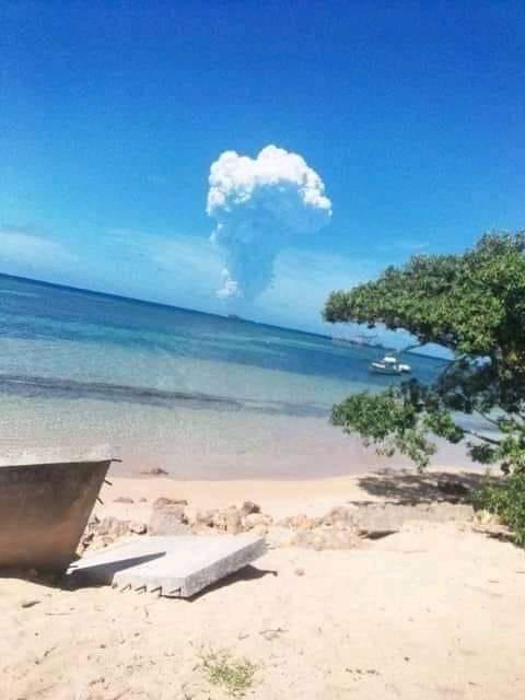
As a large gaseous cloud continues to rise to 18km altitude and drift over all islands, all Tongan residents were advised by geologists to protect their water tanks from possible acidic rainfall, until the volcanic eruption ceases.
Hunga Ha’apai is located 65km NNW of Nuku’alofa, from where the bright white gas cloud can be seen on the horizon.
Bursts of lightning at the top of the 18km high cloud were seen from Nuku’alofa and the Kanokupolu coast last night.
“It was a spectacular sight, the lighting over the gaseous eruption,” said Head Geologist, Taaniela Kula.
Shane Egan, who saw the volcanic lightning from Kanokupolu when he was out surfing said, “The lightning was running vertically down the sides of the vapour column. I must have seen a dozen or more bolts during my surf. When the volcanic vapour clouds get high enough they create their own electrical storms. So awesome – the power of nature.”
The Tonga Geological Service monitoring update said the intermittent gaseous and water vapour emission from Hunga Ha’apai had been consistent all day.
While the eruption is considered to have a low impact on the environment, they advised all Tongans to protect their water supplies from possible acidic rain.
“If the eruption dusts and ash are associated with rain it can result in a slightly acidic rainfall (pH 2.5-5.0). The acid will typically be dominated by hydrochloric acid (HCl) and sulfuric acid (H2SO4) arising from the plume gases HCl and sulphur dioxide (SO2),” they said.
“All Tongan residents are advised to remove guttering systems from rainwater water tank storages until the volcanic eruption ceases and reinstall after the next rainfall event, to reduce risk of contamination from potential ashfalls during this event.”
Symptoms of exposure to acid rain are itchiness and skin irritation, and blurry and discolouration of vision.
“If eyes or skin are exposed to acidic rain, please see a medical doctor or physician for appropriate treatment,” they advised.
Taaniela Kula confirmed that Monday’s eruption of volcanic ash and dust occurred between 9:30-9:40am, originating from Hunga Ha’apai, determined from NOAA/CIMSS HIMAWARI 8 AHI satellite imagery.
The eruption initially reached 3-16km altitude in a mushroom formation with a 30km radius, and during the rest of the day reached 18km altitude over the ‘Otu Mu’omu’a and ‘Otumotu Lulunga of Ha’apai, as well as ‘covering Tongatapu and ‘Eua.
On 20 December, the ash/dust eruption maintained 18 km altitude and reached over the Vava’u Islands including Fonualei Island. At 7:00pm, it reached Niuafo’ou Island and beyond. At 9:00pm, it reached Niuatoputapu and Tafahi Islands, he said.
The ash cloud cleared Tuesday, but the gaseous emission continued with the cloud formation drifting over Tonga.
SOURCE: TONGA WIRES/PACNEWS


